- aviationmegastore.com
- aviationoutletstore.com
- Ship to United States
Quick Search
Aviation Shop
categoriesFrequent buyers programme
Collect Megapoints for Megavouchers
Read the conditions...
Hold & Store service ©
Aviation Megastore offers unique Hold & Store service © for internet customers that wish to combine several individual orders to one single shipment, reducing the overall shipping cost significantly.
Read more...
Mega Scenery Earth Version 3, Texas V3 (North Eastern) (Download version)
Product code DL-MSEV3-TXNE
Series FSX, FSXSTEAM, P3D
Publisher/Brand PC Aviator
Version Download
Category Flight Simulation
Subcategory FSX Sceneries » FSX Mega Sceneries Earth
Availability Product out of stock and no longer available.
This product is available for download immediately after confirmation of receipt of payment. By accepting our terms and conditions confirms that the statutory 14 days right of withdrawal for internet purchases by EU residents will not be applicable to this product and the buyer waives his right of recall.
Everything is bigger in Texas and so is its recreation in MegaSceneryEarth! 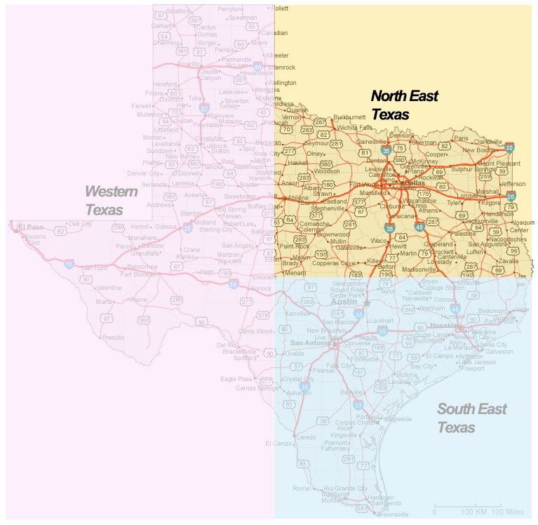
Anything we say doesn't do a photorealistic rendition of scenery for Texas justice. Texas is supermassive in every way with a phenomenal number of airports, major well known modern cities, an incredible highway system and infrastructure, an incredible aviation infrastructure, diverse terrain from rich green flatlands in the east to mountainous deserts in the west and just so much more!
MegaSceneryEarth 3 - Texas, puts the entire state of Texas into your Flight Simulator X for an amazing experience flying over then state in photoreal detail.
This is the state that Texans and non-Texans alike have been waiting for!
Because of its huge size, we have divided Texas into 3 sections.
This particular page title is North East Texas and is approximately 75,000 square miles. It includes the major metropolitan area of Dallas/Fort Worth.
The text below describes the complete state of Texas, this particular page is for ordering North East Texas only. The image shows the area covered.
|
The New MegaSceneryEarth Texas North East V3 featuring unsurpassed image sharpness, scenery color and clarity, improved scenery features with accurate additional water bodies and topographical data and the latest aerial imagery available taken in 2016. Fly the entire state - BORDER to BORDER - of Texas in photoreal detail. You'll see everything that you see in Texas in real life in the scenery. As an added bonus, we now provide all the VFR and IFR charts in digital PDF format to enable you to get the most out of your scenery. This includes 7 Sectionals, 2 Terminal Area Charts, 6 IFR enroute charts, 2 Terminal Area Charts and a 1709 page book of Instrument Approach plates, Airport Diagrams, SIDs and STARs, and an Airport Facility Directory. The charts are downloadable along with your scenery files. Cities: Dallas/Fort Worth, Houston, San Antonio, Austin, El Paso, Corpus Christi, Laredo, Lubbock, Amarillo Lakes & Water Bodies: Toledo Bend Reservoir, Sam Rayburn Reservoir, Lake Texoma, Richland Chambers, Lake Livingston, Falcon Lake, Lake Amistad, Gulf Of Mexico Shoreline Mountains & Hills: Guadalupe Peak (8,717 feet), Bush Mountain, Shumard Peak, Bartlett Peak, Baldy Peak and a total of 50 peaks above 6,700 ft. State Parks & National Forests: Black Kettle & McLellan Creek & Rita Blanca National Grasslands, Angelina, Davy Crockett, Sabine, Sam Houston, Caddo/LBJ National Forests, Guadalupe National Park, Major Rivers: Rio Grande, Red River, Brazos River, Sabine River, Colorado River, Pecos River Discover the rest of it all for yourself! There's a LOT to see in this massive state! When you order the DVD disk set you will still receive download links. If you do not wish to download, simply wait for your DVDs to arrive in the mail.THIS TITLE COMES WITH A FULL SET OF FAA AERONAUTICAL CHARTS FOR Texas IN PDF FORMAT. Here's what you get (download links for charts will be given to you with your product download): SECTIONAL CHARTS: Albuquerque, Brownsville, Dallas/Fort Worth, Houston, Memphis, San Antonio, Wichita TERMINAL AREA CHARTS: Dallas/Fort Worth, Houston VFR FLYWAYS PLANNING CHARTS: Dallas/Fort Worth, Houston LOW ALTITUDE IFR CHARTS: ELUS-05/ELUS-06,, ELUS-15/ELUS-16, ELUS-17/ELUS-18, ELUS-19/ELUS-20 HIGH ALTITUDE IFR CHARTS: EHUS-05/EHUS-06, EHUS-07/EHUS-08 AIRPORT FACILITY DIRECTORY: A FULLY INDEXED 170 PAGE PDF BOOKLET APPROACH CHARTS & AIRPORT DIAGRAMS: A FULLY INDEXED 1709 PAGE PDF BOOKLET |
|
| Details | |
| SKU: | DL-MSEV3-TXNE |
| COMPATIBILITY: | FSX/FSX:SE/P3D V1.X/P3D V2.X/P3D V3.X/P3D V4.X |
| AREA SIZE (Sq. Miles): | 75,000 |
| DOWNLOAD (Mb): | 43,400 |
| DOWNLOAD TIME (1 Gb, 300, 100, 50 Mbps): | 10 Mins, 30 Mins, 90 Mins, 180 Mins |
| NOTES 2:: | You will be sent a license number to activate. if you do not receive in your e-mail, please login to your account and you will find your license number attached to your order. |
| DATE OF AERIAL IMAGERY: | 2016 |
Shopping cart
Your shopping cart is empty.
Login
Shop near Amsterdam-Schiphol Airport. LOOK INSIDE !
When in the Netherlands,
visit our shop near
Amsterdam-Schiphol Airport.
Click on the image below for
extended tour.

- aviationshopsupplies.com
- aviationmegatrade.com