- aviationmegastore.com
- aviationoutletstore.com
- Ship to United States
Quick Search
Aviation Shop
categoriesFrequent buyers programme
Collect Megapoints for Megavouchers
Read the conditions...
Hold & Store service ©
Aviation Megastore offers unique Hold & Store service © for internet customers that wish to combine several individual orders to one single shipment, reducing the overall shipping cost significantly.
Read more...
The Pilots "Free Flight" Atlas of Eastern Hemisphere
Product code 300036482
Publisher/Brand Absolutezero
Format a4
No. Pages 208
Version Sb
Language English
Category Pilot Shop
Subcategory Aeronautical Charts » Atlas
Availability Product out of stock and no longer available.
Overview-maps : 27 pages
Europe-coverage : 96 pages, scale: 1: 2,000,000
South-Africa-coverage: 8 pages, scale: 1: 2,750,000
Mid-East & Asia : 54 pages, scale: 1: 4,000,000
Captains Corner : 39 pages
_______________________________________________________________________________________
Description : JNC scale, topographical charts are used showing over 4,500 airports
Waypoints, VOR/DME, NDB´s and special use airspace are included, plus weather frequencies, points of interest, landmarks, airport-directory with ICAO-codes, railways, rivers, major highways, just to name a few. Airports are colour coded by runway length and surface. International/ regional Aerodromes are coded by symbol shape. Pilots now have the ability to point out objects on the ground or know immediately where they are in relation to surrounding airports or points of interest: an all-in-one source of information for pre-flight or during flight.
_______________________________________________________________________________________
Overview-maps : 7 double-pages overview maps containing the following areas:
1 double page North Atlantic routes
1 double page African continent
2 double pages Asia routes to Japan
1 double pages Pacific routs
1 double pages Australia routs
1 double page North pole and starchart … and
4 pages Satellite picture Europa & Asia with mainwinds avrage,
2 pages Europe & Asia political map, 1 page star chart , 1 page polar chart,
2 pages timezones with web-suffixes,
__________________________________________________________________________________________
Captains Corner : 39 pages of aeronautical information updated with the latest JAA information.
To the Airport Directory in the Captains Corner, we have added the coordinates (Lat / Long) for every airport. World Aircraft Registration, Volmet-Broadcasts, Weather Symbols, Metar, Climb Gradients, Conversion Tables, Crosswind Component, Holding, Aerodrome Operating Minima,
De-icing Table, Aerodrome Signs + Signals and Abbreviations and…..
_______________________________________________________________________________________
Shopping cart
Your shopping cart is empty.
Login
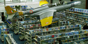
Shop near Amsterdam-Schiphol Airport. LOOK INSIDE !
When in the Netherlands,
visit our shop near
Amsterdam-Schiphol Airport.
Click on the image below for
extended tour.
- aviationshopsupplies.com
- aviationmegatrade.com